Shopping for a waterfront lot at Reynolds Lake Oconee can feel exciting and uncertain at the same time. You want the right mix of views, boat access, and long-term value, but it is not always obvious what to look for along the shoreline. In this guide, you will get a clear, practical framework to evaluate lots in Greene County so you can move forward with confidence. Let’s dive in.
Quick evaluation framework
Use this short list to compare lots quickly before you make an offer:
- Shoreline condition and management: Look for erosion, stabilization type, and any recent repairs. These can impact costs and future design choices.
- Water depth and usable frontage: Confirm depth at normal and low pool and how frontage is measured for the lot.
- Cove vs main-lake exposure: Balance privacy and calm water with views, wave action, and maintenance needs.
- Dock eligibility and design: Understand who must approve, common size limits, and setbacks so you know what is feasible.
Each factor affects cost, timeline, permitted use, and the long-term enjoyment of your lake life.
Shoreline management basics
What to inspect on site
Start with what you can see and touch. Walk the bank and note the current shoreline type, such as natural vegetation, riprap, or a bulkhead. Look for active erosion, exposed roots, slumping, or sediment buildup at the waterline. Check upslope areas for drainage features like swales or retaining walls that direct runoff. Ask about recent repairs, vegetation changes, and any warranties that transfer.
Stabilization options and tradeoffs
Different shoreline treatments have different costs and maintenance needs:
- Natural or vegetated buffer: Best for ecology and often lower maintenance if the bank is already stable. It may require wider buffers that limit lawn or hardscape near the water.
- Riprap rock armoring: Efficient at reducing erosion from boat wakes and waves. It can be visually prominent and may require permits.
- Bulkhead or seawall: High protection for steep banks. These often cost more and can increase erosion for adjacent properties.
- Living shoreline solutions: Bioengineered methods like coir logs and native plantings blend protection with habitat. Feasibility depends on slope, wave energy, and substrate.
Pick solutions that fit your site’s energy, slope, and long-term maintenance comfort.
Rules to confirm before work
In Reynolds Lake Oconee, expect a combination of community standards and external approvals. Community Architectural Review Board criteria may guide allowable shore treatments, materials, colors, and project timing. Reservoir operator rules often apply to any work in or near the water. Local and state permits can be triggered by fill, dredging, or work in regulated buffers or wetlands. Always confirm requirements with the Reynolds ARB, Greene County, and relevant environmental agencies before you begin.
Smart questions for sellers and contractors
- Has the shoreline been stabilized? When, by whom, and with what materials?
- Are there warranties or maintenance agreements you can assume?
- Are there restrictions on certain erosion control types?
- Have any permits been issued for shoreline work or dredging in the past?
Water depth and frontage
Depth and boat needs
Depth at the proposed dock site drives your boating options. Inboards, wake boats, and larger pontoons need deeper water. Confirm depth at both normal and managed low pool levels where you plan to place the dock or lift. Ask how far you must travel to reach the deeper navigation channel. If water is shallow near shore, you may need a longer gangway, dredging, or a different dock location.
How frontage is measured
Frontage is often measured along the shoreline at the high-water mark, but the exact method matters. Review the recorded survey, deed, and community definitions for how Reynolds and Greene County handle frontage measurements. Confirm riparian rights in the deed, because ownership and use of submerged lands in reservoirs can differ from natural lakes. The way frontage is defined can affect dock placement and setback rules.
How to verify on site
Bring a contractor or surveyor to take recent depth readings at the intended dock location. Walk the shoreline at low pool when possible, or request low pool measurements and photos. Look for signs of shoaling, muck, or vegetation that can affect use and maintenance. Measure sunlight, orientation, and fetch to estimate wind and wave exposure.
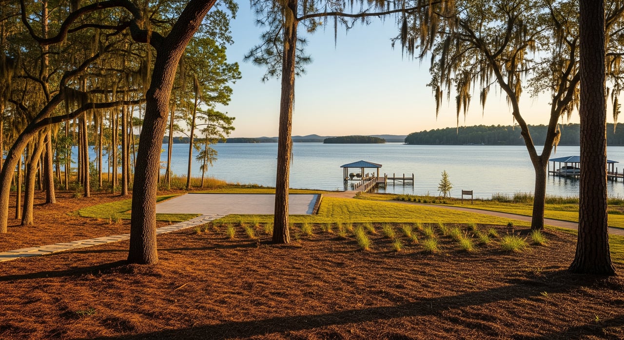
Cove vs main-lake exposure
Cove pros and cons
- Pros: Calmer water, easier docking and swimming, and often more privacy and quiet. Coves can feel more sheltered for kayaks and paddleboards.
- Cons: Coves can accumulate sediment and aquatic vegetation and are sometimes shallower. Water circulation may be lower, which can affect clarity at times.
Main-lake pros and cons
- Pros: Bigger views, deeper water closer to shore, and quicker access to open water for larger boats.
- Cons: More wind, wakes, and boat traffic. Shoreline erosion risk is higher, and docks may require more robust designs.
What it means for you
Match exposure to your lifestyle. If you prize easy swimming, calm mornings, and quiet afternoons, a cove may fit. If you want sweeping views and quick runs in larger boats, main-lake exposure may be ideal. Factor long-term maintenance into your budget and timeline.
Dock eligibility and permits
Who typically approves
Expect multiple approvals for a dock or boathouse at Reynolds Lake Oconee:
- Reynolds Lake Oconee Architectural Review Board for community design and placement standards.
- The reservoir operator for shoreline management and activities on submerged lands.
- Greene County for building, zoning, and health department requirements near the shoreline.
- State and federal agencies if your project affects regulated waters or wetlands.
Small, straightforward docks can sometimes move through a streamlined process, but you must confirm locally.
Common limits to expect
Typical dock rules include maximum length and width, setbacks from side property lines, approved materials and colors, and restrictions on roofed structures or boathouses. Some communities specify allowed boat lift types. Plans stamped by an engineer and licensed contractors may be required for larger structures or stabilization.
Permit triggers to know
Work that often requires approvals includes pilings or permanent structures in the water, riprap or other fill for stabilization, dredging below the ordinary high-water mark, and construction over water. Projects touching wetlands or buffer zones can require additional review.
Timeline and cost drivers
Plan for a staged process: community ARB review, reservoir operator authorization, county permits, and state or federal approvals if needed. Straightforward docks on managed reservoirs can sometimes be approved and built in 2 to 3 months. Complex shoreline stabilization with engineering or dredging can take longer. Costs vary with design complexity, materials, engineering, dredging, and any mitigation required. Get multiple written bids with clear scopes.
Pre-offer due diligence checklist
Use this checklist to strengthen your offer and avoid surprises.
Documents and data to request
- Recorded lot survey showing shoreline, lot lines, and easements.
- Deed language on frontage and riparian rights and any covenants about shoreline use.
- Reynolds Lake Oconee ARB guidelines and any lot-specific restrictions.
- Copies of previous shoreline or dock permits, contracts, warranties, or inspections.
- Shoreline repair history and any pending community shoreline projects.
- Bathymetric map for the cove or shoreline area and recent depth readings at the proposed dock site.
- Recent lake level history to understand normal and managed pool ranges.
- Wetlands confirmation or a professional delineation if needed.
- Soil and geotechnical input for larger stabilization or structural work.
- Utility and septic locations and setbacks that could influence site planning.
- Contacts for local shoreline contractors, marine surveyors, and engineers with Lake Oconee experience.
- A written estimate of time to obtain approvals for both dock and shoreline work.
- Information about adjacent shoreline treatments, such as riprap or bulkheads, that can influence erosion.
On-site checks to perform
- Walk the shoreline at low pool or obtain low pool measurements and photos.
- Inspect for shoaling, muck, and debris along the waterline.
- Measure sunlight, orientation, and open-water fetch to gauge wave exposure.
- Test boat access to the navigation channel and note distance to marinas.
Questions to ask the seller or listing agent
- Has the lot required dredging or major shoreline repair in the past? If so, how often and who did the work?
- Are there any open ARB violations, variances, or nearby rezonings?
- Who maintains the shoreline and at what cost and interval?
- Are any community shoreline or navigation changes planned?
Build smarter at Reynolds Lake Oconee
When you understand shoreline condition, water depth, exposure, and dock feasibility, you can compare lots with clarity and negotiate with confidence. This is especially important for tear-downs or custom builds where site design depends on dock placement, lift style, and long-term erosion control. The right homework protects your investment and preserves your enjoyment of the lake.
If you would like a second set of eyes on a short list, a pre-offer walk-through, or help coordinating surveys and depth readings, you can lean on a local, concierge advisor who knows the Reynolds communities and Greene County processes. Our team supports in-person and remote buyers with virtual showings, valuation tools, and white-glove coordination from offer to close.
Ready to evaluate a lot or start a targeted search at Reynolds Lake Oconee? Reach out to Madison Reed when you are ready to talk strategy, timing, and next steps.
FAQs
How do I check dockable depth for a Reynolds Lake Oconee lot?
- Bring a contractor or surveyor to take depth readings at the intended dock location at normal and low pool, and verify the distance to deeper water or the navigation channel.
What counts as water frontage in Greene County, GA?
- Frontage is often measured along the shoreline at the high-water mark, but you should confirm the exact definition in the recorded survey, deed, and any Reynolds community standards.
Do I need permits to place riprap or a seawall on Lake Oconee?
- Shoreline stabilization, including riprap or bulkheads, commonly triggers approvals; confirm requirements with the community ARB, the reservoir operator, and local or state agencies before starting work.
Is a cove lot or a main-lake lot better for resale?
- It depends on buyer preferences; cove lots favor calm water and privacy while main-lake lots favor big views and deeper water, so focus on the exposure that best fits your long-term lifestyle.
How long does dock approval usually take at Reynolds Lake Oconee?
- Simple docks on managed reservoirs can sometimes be approved and built in 2 to 3 months, while projects that include dredging or significant shoreline work often take longer due to additional reviews.